Sunday, June 27, 2010

Towards the Top

The Locals, Aileron
Wednesday 23 June, heading north to the furthermost point in the Territory, namely Darwin. 1500 kilometres to reach 30C plus temps and see the ocean, yeah! Not quite, in this case the Arafura Sea.

Collected the two white "heelers" and headed out of the Alice. Quick stop at Aileron to see the giant sculptures of the Ammatjera man, woman and child which are eye catching in the flat landscape. The Ammatjera country is known as the growing area of the center and produces melons and grapes. There are a lot of aboriginal communities all through the areas we have travelled in the center and we have become accustomed to seeing the blue and white signs to the Aboriginal communities, "No Alcohol, No Pornography" or Adrian's translation, "No Piss, No Dirty Pictures"!

Taylor Creek campsite for the night, a freebie with fifteen vans including ours. Thursday morning first fuel stop at Tennant Creek after driving by the Devils Marbles from the opposite direction - again so impressive. Ade came out of the fuel stop to tell me we have a new Prime Minister and a woman for the first time. Look what happens when you don't have phone or internet for 24 hours!

North past the 3 ways where the Barkley and Stuart Highways meet but no turn off to Queensland for us. Different landscape now and we notice the increase in temperature. A sign to Bootu Creek a magnesium mine, and further on the sides of the road were lined with hundreds of orange flowering bottle brushes their silver foliage glistening in the sun. Helen Springs Station on the right, one of the Kidman clan owned stations dotted throughout the country. Sidney Kidman a pastoralist left his mark by purchasing properties from the north to south enabllng the mustering of stock along a good food chain early in the last century. Just a little history here to see if you are paying attention.

Ammatjera Woman & Child

Ice cream stop at Renner Springs, yep, it's getting warmer and now the country is supporting taller and thicker trees and flowering wattles. To the west Lake Woods came into view. Ade said it's a mirage and so it looked at first until we checked the map. The last time we saw this much water was at Mt. Isa. Elliott is our overnight stop and we wonder if our Winton dinasaur comes from here!

Friday a stop at Dunmarra to say g'day to Gary Frost, Mick's dad, our neighbour and mate from Sinnamon Park. Gary runs the Road House and Caravan Park and as we hadn't planned on a lengthy stay we have promised to spend more time on our next trip. We left the desert behind and entered forest country and for the first time in weeks we noticed the humidity. Larrimah our lunch stop, a recommendation, to try the "famous" pies - the most tasteless and expensive we have eaten. These get a Yuck rating!

Mataranka is the next town and is known as the Capital of the Never Never. The area was home to Aeneas and Jeannie Gunn. Jeannie wrote the famous book "We of the Never Never" set at Elsey Station. The homestead and grave sites are all there to see. Mataranka was also home to a WWII airfield for our Aussie fighting boys.

Onwards to Katherine, "where the Outback meets the Tropics"!

West MacDonnell Range

On our last full day exploring the center we travelled 130 kilometres west of Alice and our first stop was at Ormiston Gorge. The water is over 14 metres deep and icy cold - I didn't test it out. We saw Port Lincoln parrots and Zebra finches here and I think the photos are better than my descriptions.


Ormiston Gorge


Five minutes further out, Glen Helen Gorge situated on the Finke River, provided another view entirely. We stopped to buy an icecream and I noticed some Aboriginal women sitting on the ground painting. Their dot paintings were in various stages, one just a square border, one partly completed and another which looked finished. They didn't speak English but understood enough to nod when I asked for the photo. The ladies were lunching at the time and I was truly fascinated with their contented faces. I think this was one of those "being in the right place at the right time" experiences.


The ochre pits where only the Aboriginal men were allowed to collect the ochre was used for body painting by both men and women in the sacred ceremonies. A very peaceful place in a rocky and dry river bed.


Ochre Pits

Last stop on our return was Simpsons Gap, a sandy river bed between enormous cliffs and as the sunshine was finished for the day it was getting cold, and time to head back and take advantage of our last night of "puppy freedom" to go to a restaurant for dinner.

Mt Sonder


Pack up time Thursday morning, collect the four legged people and tropics here we come!

Kings Canyon (Watarrka National Park)

Kings Creek Station Resident

Left Yulara Sunday morning and headed east on the Lasseter Highway passed Curtin Springs and then turned north on Luritja Road and onwards to Kings Canyon a further 170 kilometres. The Canyon is situated in the Watarrka National Park and encompasses the western end of the George Gill Range and as we climbed and traversed this winding road we could see the West Macdonnells in the distance. About seventy kilometres from the turn off we saw the unsealed corrugated dirt road which is a shortcut back to Alice Springs. Don't think we will use this on the return journey.

Kings Canyon &The Count and Countess of No Account
Ten kilometres out of the Kings Creek Station we start to see Australia's version of the Grand Canyon. Elevation 2017 feet according to the sign - no metric here, or phone and internet. Camped overnight at this working cattle station which is also an exporter of camels and the largest camel station in Aus (there's that "biggest" title again). These one's have really sweet faces.


The Canyon is breathtaking to walk into especially with the late afternoon sun casting highlights and shadows across the rocky base. The Luritja people have been the custodians of the Wartarrka area for thousands of years. We took the Kings Creek (Wartarrka Karu) walk along a very rocky and moist river bed which is rich in plant life inlcuding red river gums, wattles, grevilleas, bottle brushes, all in flower, and many more to numerous to mention in this space. Some of the rock formations have a beehive shape with a circular pattern and layers of different colours. I will let the photos do the talking.


The Bottom of the Canyon


Layer upon Layer

Monday back to the Alice and a stop off for lunch at Erldunda. Home made meat pie for me (very yummy pastry), and Ade broke the chain and had chicken and chips. Just past the turnoff on the side of the road I spied two enormous Wedge Tail Eagles, black and bronze in colour, waiting for some unsuspecting prey I suspect. Magnificent sight!


A different caravan park in Alice Springs this time with clean amenities and grassed areas. Wish we could have had the woofs here first time round. Tomorrow we will investigate the West MacDonnell Ranges.

Uluru-Kata Tjuta National Park

Kata Tjuta (The Olgas)

Saturday back to explore more of this National Park. My plans to climb the rock have been foiled by high winds and the climb is closed. On to The Olgas approximately 50 kilometres down the road. Ade describes the difference in the structure as Uluru being one big rock and the Olgas as billions of small (20 to 50cm) rocks held together with concrete like sand. Kata Tjuta (Aboriginal words, translation, many heads) is a pile of 36 massive weathered rock domes estimated to be 500 million years old. We had a big day of walking and climbing up rocky paths to the Valley of the Winds to the Karu Lookout and then into Walpa Gorge a moist desert refuge for flaura and fauna.


Valley of the Winds


Entering Walpa Gorge


Walpa Gorge Return
Returned to Ulura and the climb was still closed. Walked along the base on the Mala Walk and viewed faded cave paintings and further on the Kantju Gorge which provided the main drinking water for the Aboriginal people. One of the caves is sacred to the women from The Dreamtime, the Aboriginal stories of creation and law, and is known as the "wallaby's womb". We were asked not to take photos as it disturbs the spirits, and being true believers we acceded to their wishes. The photos we have taken can't really capture the enormous height of the walls but they are probably better than any more words.


Uluru Base


Looking to the sky from the base


We had walked over ten kilometres so a hot shower and a few glasses of the grape were very welcome at the end of this day.

Saturday, June 26, 2010

Alice to Curtin Springs and on to Yulara and Uluru

Gertie, the Emu

Thursday 17 June headed south on the Stuart Highway; could end up in Adelaide if we continue in a straight line. Destination is Curtin Springs Station for the night. Changing scenery, red rock hills and bright orange sandy soils, dry river beds and then we entered moonscape country before the turn west on to the Lasseter Highway at Erldunda.


Mt Conner


The third of the great rock formations of the red center came into view east of Curtin Springs. Mt Conner is a spectacular stand alone massive rock and sand table top mountain, 700 million years old. Ade's poetic description of Mt. Conner, "a fortress wearing a tutu!". Down the road a way we saw a huge wedge tail eagle sitting on the side of road eating a roo carcass. A stunning sight in this desert but not able to stop the car and van at 100 kph to take a photo. Curtin Springs Station is our first free camping experience; ie. no connected water and power and we "done good". We settled in once we figured that we had correctly turned the refrigerator to gas, and I realised the microwave wasn't going to work on battery. Dry and dusty and red dirt everywhere and more sensational views at sunset of Mt. Connor with a magic pink, purple and red sky. Resident Emu we named 'Gertie' came visiting making her own unique rumbling burping sound.


Red Dirt and Sunset
Our Van - Curtin Springs Station
Friday 100 kilometres to Uluru, the big rock and I am very excited. Scenery has changed to prehistoric times; She Oak type trees with a straight trunk and weeping foliage and later on we found out that they are Desert Oaks and common in this part of Aus! Our first glimpse of Uluru, one of the worlds natural wonders, about 50 k's out of Yulara is spine tingling. Yulara is a purpose built town for campers and visitors in general, supporting the "tourism" and protecting this heritage area. A great campsite where we met Dave and Sandra from Albury and their beautiful Doberman, Gemma who so reminded us of our Xandria. It was great to have a Dobe fix again. Unhitched the van and headed out to see Uluru close up, and I wonder how do you describe this massive rock in the very center of Australia. It's more spectacular than all the photos.
Uluru

We drove around Uluru which rises 348 metres and 9.4 kilometres girth. At least two thirds of this weathered rock are under the surface. The local Anangu people regard Uluru as a sacred site and discourage visitors from climbing. The cultural centre was well worth wandering through to learn about the way of life, religion, philosophy and knowledge of the local Aboriginal people. I found their food and medicine, sourced from the native vegetation a very interesting read. Tomorrow I'm hoping to climb or partly ascend this gigantic rock.


The Climb

Monday, June 21, 2010

Alice Springs


To reach Alice Springs we went south over the Tropic of Capricorn. The Alice is nestled in a gap between the East and West Macdonnell Ranges which is an impressive sight approaching the town. These ranges are over 400 kilometres long. Caught up with time out on Friday and Saturday put on our exploring shoes once again.


Emily Gap


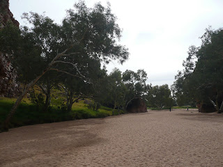
The East Macdonnell Ranges are stunning and we stopped at Emily Gap, Jessie Gap and Corroborree Rock. Spectacular scenery - dry creek beds of coarse red sand and pools of water nestled between rocky mountains with beautiful red river gum trees and lush undergrowth. Flocks of our precious native green budgerigars and beautiful parrots with black heads, yellow necks and bright green wings which I later learned are called Port Lincoln Ringneck Parrots.

Jessie Gap

Spent Sunday afternoon with Barb and Neil (my girlfriend Marg's sister and brother-in-law) and also Di (Marg's other sister) who was up from Melbourne. Poor little Bere made a spectacular entrance by falling into the swimming pool and luckily he was still on his leash so I could haul him out without going in after him. Barb spoiled us with home made scones,and cream and jam of course, baked cheesecake and a choc slice. Home cooking of a different kind for us - delicious!. We had a delightful interlude to our camping style existence.

Corroboree Rock

Monday, Queens Birthday holiday and a long weekend and time to explore one section of the West Macdonnell Ranges. Our destination Hermannsburg, a very old German mission settlement and also Albert Namitjura's (our most famous aboriginal artist) birthplace. The colours of the mountains range from the darkest reds to bright orange/pink and I'm told a greener tinge that has not been seen in the center in recent years. Lake Eyre has filled two years in a row and according to the locals you can see the result of the increase in rainfall. The tiny town was originally a Lutheran Mission and the white washed stonebuildings are a stark contrast to the surrounding country. There are three main buildings, a church with a bell strung out from a tree, a building that looks somewhat like a jail, and the main one which has been turned into a tea room and an aboriginal gift shop with paintings and craft.


Hermannsburg Church

On our return journey we pulled into Standley Chasm and Simpsons Gap. Small glimpses of stunning formations and part of the National Park so cannot take dogs out of the car.

We timed our visit to the Alice for the "world famous " (never heard of them) Finke Desert Dirt Bike Races which are an off road race for bikes, quads and modified cars. Mass departure of campers on Tuesday after the weekend event. Very cold overnight, minus three degrees and both dogs not well; this isn't a very clean caravan park. The only one that takes dogs so we have no choice.

Wednesday we left our four legged childen in safe keeping in the hands of two sisters who run a kennel where all woofs are indoors and will have their pj's on at night to keep warm. I feel now they are at least in a cleaner environment than the park.

We are heading out Thursday to Uluru, the Olgas and Kings Canyon.

Tennant Creek, Barrow Creek to Ti Tree


From the Barkley Homestead we continued due west on the Barkly Highway and then south on the Stuart Highway at the T junction, for 23 kilometers to Tennant Creek. Flat and boring bush country and a freezing morning. The McDowall Ranges made a welcome change to the vista driving into this town. There are stunning views of the ranges from the Bill Allen Lookout just out of town and we stopped at the Battery Hill Mining Centre to check out the history. Gold is still extracted from the ironstone rocks here even though it is difficult process. Tennant Creek grew on the back of Australia's last gold rush in the 1930's when gold was discovered by linesman laying the Overland Telegraph cable between Adelaide and Darwin.

The town today supports a large aboriginal community (no doubt on government handouts as there appears to be no employment to speak of) and for me it was a culture shock. Invent a game and call it "Spot the White Fella"! This is not a happy place; no smiling faces. We observed very young girls who should have been in school, pushing prams, people and dogs sitting on the ground outside the local shops or aimlessly wandering the streeets. I was happy to sit in the car while Ade bought some bread and milk and there was another shock. Trim milk was $5.30 for 2 litres. It seems that the locals are on welfare and without education will pay whatever the shopkeepers charge. They simply don't know any difference.

Wednesday south bound and adjacent to the Davenport Ranges a must stop and see destination, the Devils Marbles or the Aboriginal name, Karlu Karlu. This Dreaming site is a sacred place for the local Aboriginal people and they believe people from the Dreaming live under the rocks in the caves. This is a spectacular outcrop of granite boulders and are truly amazing. Precariously balanced boulders on top of one another and others split in two and appearing to be balanced on point which have actually been worn away by wind and rain and eventually crack apart. There are mens and womens Dreamtime stories but the one I like relates that these boulders are the Rainbow Serpents eggs.


Passed by the town of Wycliffe, one pub and a park, famous for its UFO sightings. The only thing we saw was a cloud formation resembling a flying saucer. Probably to much "piss" consumed here according to the male sitting next to me. Countryside now supporting red flowering native bushes, which looks like a grevillea, amongst the flowering wattles and flocks of green budgerigars who were doing kamikaze flights across the car with Ade yelling at them to get out of the way.


Barrow Creek was to be a one night stop over but owing to the lack of white faces in town we decided to push on another 90 klms to Ti Tree. We did stop at Barrow Creek to look at the historic telegraph station buildings constructed of stone and the grave of a station manager and linesman who were murdered by the local Aboriginals in the early days. Ade reminded me this was the area where Peter Falcone "disappeared" and then of course there was the film "Wolf Creek" set in Barrow Creek. For my international readers, this was a murder of a young English tourist who was travelling with his girlfriend. She ran off into the bush and eventually flagged down a passing car for help. The killer is now spending the rest of his life in one of Her Majestys establishments. Falcone's body was never found. No it wasn't a place I wanted to spend a lot of time.

Ti Tree was like being on the South Pole at night with gale force winds and a chill to freeze your bones! Other than the temperature it was an okay one night stop! Alice Springs the next destination and on our return journey hope to stop by a few places we misssed.

Monday, June 14, 2010

Mt Isa to the Border and Beyond


Trekking west again. White flowering gums, craggy red rock formations and hilly country on the way out of Cloncurry on the Barkly Highway. The Burke & Wills memorial commemorating where the explorers camped by the Corella River was worth a stop and then further down the road we checked out the turn off to Fountain Springs, which are permanently filled springs filtered through layers of quartz according to the sign. 24 klms of rough dirt road - maybe next time.

Mt Isa on the horizon is quite spectacular with the three smelter stacks smoking away, and the town set amongst the ore rich Selwyn Ranges on the banks of the Leichhardt River. It borders the Savannah country to the north, rich cattle country to the south, Simpson desert to the west, and pastoral counry to the east. The Isa is home to one of the worlds biggest underground copper, silver, lead and zinc mines. Also the biggest and richest rodeo in Australia which features a packed programme of events for a week every August.

Mt Isa Smelter Stacks

Our first night in the Caravan Park we were entertained by a very loud concert close by and as you can imagine our thoughts were if this is a Thursday night, what will Friday and Saturday nights be like in this town. It was none other than Jimmy Barnes belting out his numbers at decibel overload! Fortunately for us and the rest of the guests at this camp site, it was a one night stand.

Ade hasn't been here for 42 years when he worked underground, so it was his turn to play tour guide. Lake Moondarra about 15 minutes drive, supplies water for the town and for the production of ores from the mine. Also a haven for the locals being the closest large body of water and we noted canoe races underway, fishing and boating activities, and barbeques around the shore line.

The lookout gives a great 360 degree view of the countryside. We spent a few days checking out the town and tourist areas and then it was time to keep heading west.

Camooweal was the next town on the stopover, 13 kilometres before the border. Beautiful countryside through red rock mountain ranges supported by thick grasses and low growing trees at the foothills. No doubt there has been plenty of moisture across the west this year as Ade doesn't remember it being anything but dry and dusty when he was here last. We saw more copper mines and also a phosphate project as well. This is the best highway surface so far and no road trains. They road trains are enormous with up to four wagons attached and over 50 metres long! Lunch at Camooweal and a fuel stop. Not many fuel stops in this outback land of ours.

Must be time to post another food note and this is a beauty! Do not eat meat pie in car park at Camooweal. Starving hawk swooped and knocked meat pie out of Ade's hand. Ade very pissed off. Shouted and waved at hawk and said a few rude words!

Obviously, this town is not a destination so we pushed on to the "Border" and a further 260 kilometres to Barkley Homestead and the first fuel stop. Goodbye Queensland, see you next year some time!

We were expecting these amazing roads when we reached the Northern Territory as we had been told by numerous travellers. Speed limit went from 110klm per hour to 130. Not with the van in tow, mate. Let me tell you, it was bouncy, bouncy to Avon Downs about 80 k's away which has nothing but a police station. Then the roads improved but we saw no sign of habitable existence until we reached "The Barkly Homestead'. It is an oasis in the outback with lovely shady trees and red, red dirt. We didn't unhitch the van for the one night stop before heading for Tennant Creek.

Saturday, June 5, 2010

Winton to Cloncurry


Our Winton Neighbours


Thanks to the thousands of bush flies, The Great Australian Salute was in full force to welcome us to down town Winton. US translation - please refer to Shane.


Winton is home to The Waltzing Matilda Centre, a museum dedicated to the song penned by Banjo Paterson in 1895 while he was on holidays here. Cannot imagine this place being a top tourist spot in those days, so maybe an imaginative journalist is having a lend of us! What we do know is that the song has become the ordinary man's national anthem and Australias favourite ballad. I really like his poem Clancy of the Overflow which was also written in Winton. In 1995, the 100 year anniversary of the song was celebrated and artists were commissioned to provide a variety of statues and sculptures relating to the story which are set in the main street.

I haven't yet mentioned those dinosaurs and I suppose everyone is dying to know if we found any. Sorry folks they died millions of years ago! All that's left is some old bones! The largest dinosaur found in Australia was discovered here and has been named Elliott. He was a Sauropod and a herbifore. We drove up to the "jump-up" or mesa where he was found but couldn't do the tour as our timing was off. The only recorded evidence of a dinosaur stampede is found to the south at Lark Quarry Trackways.

The area is also famous for Boulder Opal which is mined to the north at Opalton and to far for us to travel this trip. We did get to see a lot in the displays in the gem shops and I was amazed at the predominately pink and blue stones as I have mostly seen milk and black opal. We bought "bonsai" opal tree from a delightful aboriginal lady who came around to the caravan park.

Monday onwards to Cloncurry, a big haul on the outback highway. The country is predominately flat with Mitchell and spinifex grasses and lots of those woolly sheep. Passed by the turn off to Julia Creek, the Gateway to the Gulf and a place called Kurumba noted for excellent fishing which explains why there are boats on trailers towed behind lots of vehicles.


Lunch at Kynuna, once a staging post for Cobb & Co, population 20 and home to the Blue Heeler Pub and guess what was on the menu, meat pie and a pot! Rocked up to the bar of the Blue Heeler with our two White Heelers in tow. The barman, Ade observed, had only one ear and Ade asked him if he would like a beer to which the barman replied "no thanks mate I've got one ear". Gave the Caravan Park a miss though - refer photo. Down the road was the town of McKinley famous for "The Walkabout Creek Hotel" from the Crocodile Dundee movie. 40 miles out from Cloncurry, the Williams River, dry as a bone!

Adrian and the two White Heelers


The Bartender in the Blue Heeler Pub


The 'Curry' as it is affectionately known, was predominately a grazing and mining area in the early days. It is home to the John Flynn Place Musuem, which celebrates the visionary bush clergyman who was the founder of The Royal Flying Doctor Service. Along with Hudson Fysh, the Qantas founder, his dream was realised in 1928 when the first flight took off with a doctor on board. Alfred Traegar's (the inventor) first pedal wireless is on display at the museum. Without electricity, this wireless communication was integral to the success of the service. The School of the Air which first started in 1950 also came about through the efforts of Flynn and Traegar.

We stayed at one of the friendliest parks so far and made new friends, Ian and Carol from the Sunshine Coast, who just happen to have a four legged fluffy bum, (at home with a babysitter this trip) and very willling 'dog sitters" for us one afternoon. It was like having a date getting out and about without Bere talking to us the whole time. Looking forward to catching up with these guys on our return.


A Saddleback hill near the Caravan Park Cloncurry

Ernest Henry discovered copper in this area in 1867 and today copper and gold is mined at the open cut mine bearing his name. There are smaller operations mining lead and zinc and in recent times a mineral called magnatite which is sold to the Chinese. We checked out the Cloncurry River and Lookout, Chinaman Creek Dam, where there are fresh water crocodiles, and Mt Leviathan. Mary Kathleen Park & Museum is located in town. It's trip down memory lane of the former uranium mining township which closed down when the mine shut down.


Thursday time to leave "the Curry" and head for "the Isa".

Tuesday, June 1, 2010

Ilfracombe to Longreach


After leaving Barcaldine on Tuesday 25 May, we headed due west through rich grazing country and saw lots of moos, Hereford as well as Santa Gertrudis cattle grazing in the paddocks. Stopped at the pretty town of Ilfracombe, the home town of our Governer General, 27klms out of Longreach and checked out the Great Machinery Mile along the highway which is an historical display of both pastoral and transport machinery. I particularly liked "Winsome Winnie from Warbreccan" an old wool wagon, which in her day was piled high with bales of wool and pulled by horses all the way to Bowen on the east coast. Didn't stop to enjoy the artesian spa which bubbles away at 37C degrees and is reputed to have wonderful healing powers.
Longreach was recognizable in the distance as we approached with the tail of a 747 and the 'Flying Kangaroo' on the horizon. Part of the Qantas Founders Museum which also houses the original hanger, a Boeing 707, and a DC3. There are various replicas of other early aircraft, my personal favourite, the Avro 540K, a tiger moth and the first Qantas aircraft purchased in 1921. The 747 200 on display is the very first jumbo purchased by the Company. Lots of fun doing the tour and seeing all the cargo bays, engines, landing gear etc, and also most interesting, where the black box recorder is kept. It's actually orange as it is the most visible colour and least flammable according to the guide. By the way the Black Box as well as the emergency slides are Aussie inventions.

Two young WWII vets and locals, Hudson Fysh (who Adrian met when Sir Hudson was Chairman of Qantas many years ago) and Paul McGinnes, started the Queensland and Northern Territory Aerial Services, as it was then known, in 1921. The first flight was out of Winton to Cloncurry before relocating the Company to Longreach. Cobb & Co were still responsible for delivering the mail into the 1920's before Q.A.N.T.A.S. took over.

A small notation here, for the girls reading this, Trevor Hendy, former Ironman was filming for a new program on Channel 10 while we were on the 747 tour. He looks 'Hot' even with his gear on - sorry fellas! As Ade says, we are just a bunch of old desperates!


Thursday saw us doing our separate tours (because we can't take the dogs with us) of the Stockmans Hall of Fame. Its a great tribute to our pioneers and early settlers and lots of interesting displays of original artefacts and stories of bush life as it was through to the present day, including how much the modern man on the land relies on the internet. Gone are the days of the bushy with his swag and billy can, of the horse and cart carrying the general store, or the mail order catalogues I remember my Aunt using on their property when I was there for 6 weeks in 1958. There was a replica of a very old map of Queensland depicting all the station properties as first settled and I found the property originally owned by my Uncle's father, which is the one I visited, and is still in the family today.


There is a great tribute to RM Williams who was the legendry crafter of stockmans boots and saddles and he was also largely responsbile for bringing about the Stockmans Hall of Fame.


Sunset at Longreach Caravan Park


Weather is getting "icy" cold at night but the days are beautiful . Saturday headed north west this time, on the Matilda Highway to Winton. Saw sheep grazing about 40 kilometres past Longreach, and kangaroos and emus as well. There was a sign, 'Lake Eyre Basin, Diamentina & Darling Rivers Catchment Area'. The water which fills Lake Eyre travels a long way! Feels like we are really in the outback, no clouds, no trees and red sandy soil.


As we approached Winton we saw Black Aberdeen Angus grazing and more interesting landscape of large mesas, gorges and jump-ups. We are entering "Dinosaur Country" - haven't seen any yet! Stay tuned - further updates coming.